About
http://www.remate.ph/2016/05/special-elections-isasagawa-sa-sarangani/
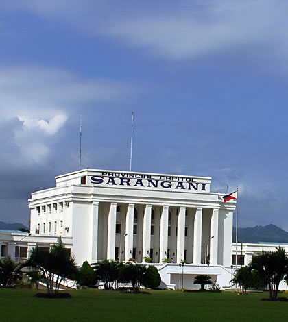
Sarangani

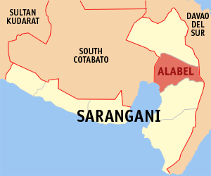
ALABEL
Alabel is a philippine municipality in the province Sarangani in Region XII SOCCSKSARGEN which belongs to the Mindanao group of islands. The municipality Alabel is seated about 1,056 km south-south-east of Philippine main capital Manila.
Alabel is a 1st class municipality. Regarding urbanization Alabel is classified as partly urban. Alabel occupies an area of 510.98 km². By the end of 2007 Alabel was the home of 71,872 residents. Thus by average 140.66 people are living on one km².
Administratively the Municipality of Alabel is subdivided into 12 barangays. One forms the center of the city wheras the other 11 are in the outlying areas. Some of them are even several kilometers away from the center of the Municipality. The most populous are Paraiso, Bagacay, Tokawal,Spring, Baluntay, Domolok, Maribulan, Kawas, Datal Anggas, Alegria, Pag-Asa, Poblacion (Alabel).
Among the bigger cities and municipalities in the neighborhood of Alabel there are General Santos City (Dadiangas) (South Cotabato) 12 km west-north-west, Malita (Davao Del Sur) 40 km north-east, Polomolok (South Cotabato) 28 km west-north-west, Sultan Kudarat (Nuling)(Maguindanao) 88 km west-north-west, City Of Digos (Davao Del Sur) 75 km north, City Of Koronadal (South Cotabato) 66 km north-west, Isulan(Sultan Kudarat) 96 km north-west, City Of Tacurong (Sultan Kudarat) 95 km north-west, Glan 31 km south-south-west as well as 28 km north of Alabel the municipality Malungon.
http://www.philippine-islands.ph/en/alabel-sarangani-philippines.html
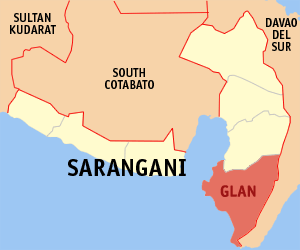
GLAN
Glan is a philippine municipality in the province Sarangani in Region XII SOCCSKSARGEN which belongs to the Mindanao group of islands.The municipality Glan is seated about 31 km south-south-west of province capital Alabel and about 1,079 km south-south-east of Philippine main capital Manila.
Glan is a 1st class municipality. Regarding urbanization Glan is classified as partly urban. Glan occupies an area of 610.30 km². By the end of 2007 Glan was the home of 102,676 residents. Thus by average 168.24 people are living on one km².
Administratively the Municipality of Glan is subdivided into 31 barangays. One forms the center of the city wheras the other 30 are in the outlying areas. Some of them are even several kilometers away from the center of the Municipality. The most populous are Rio Del Pilar, Batotuling, San Jose, San Vicente, Batulaki, Sufatubo, Cross, Calpidong, Lago, Mudan,Gumasa, Tango, New Aklan, Congan, Kapatan.
Among the bigger cities and municipalities in the neighborhood of Glan there are Sultan Kudarat (Nuling) (Maguindanao) 100 km north-west,General Santos City (Dadiangas) (South Cotabato) 32 km north, Malita(Davao Del Sur) 69 km north-north-east, Polomolok (South Cotabato) 46 km north-west, Malungon 57 km north, City Of Koronadal (South Cotabato) 85 km north-west, Banga (South Cotabato) 77 km north-west,Alabel 31 km north-north-east, Surallah (South Cotabato) 80 km north-west as well as 19 km north-north-east of Glan the municipalityMalapatan.
http://www.philippine-islands.ph/en/GLAN-sarangani-philippines.html

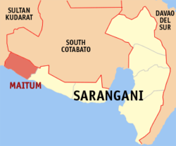
Maitum
Maitum is a philippine municipality in the province Sarangani in Region XII SOCCSKSARGEN which belongs to the Mindanao group of islands. The municipality Maitum is seated about 88 km west of province capital Alabel and about 1,016 km south-south-east of Philippine main capital Manila.
Maitum is a 2nd class municipality. Regarding urbanization Maitum is classified as partly urban. Maitum occupies an area of 290.66 km². By the end of 2007 Maitum was the home of 37,054 residents. Thus by average 127.48 people are living on one km².
Administratively the Municipality of Maitum is subdivided into 19 barangays. 2 compose the center of the city wheras the other 17 are in the outlying areas. Some of them are even several kilometers away from the center of the Municipality. The most populous are Bati-an, Kiayap,Kiambing, New La Union, Pangi (Linao), Zion, Wali (Kambuhan), Ticulab,Kalaneg, Sison (Edenton), Tuanadatu, Pinol, Kalaong, Upo (Lanao),Maguling.
Among the bigger cities and municipalities in the neighborhood of Maitum there are Sultan Kudarat (Nuling) (Maguindanao) 42 km north-north-east,General Santos City (Dadiangas) (South Cotabato) 76 km east, Malungon88 km east-north-east, City Of Koronadal (South Cotabato) 58 km north-east, Glan 86 km east-south-east, Polomolok (South Cotabato) 65 km east, City Of Tacurong (Sultan Kudarat) 65 km north-north-east, Banga(South Cotabato) 45 km north-east, Isulan (Sultan Kudarat) 57 km north-north-east as well as 72 km north-west of Maitum the municipality Lebak(Sultan Kudarat).
http://www.philippine-islands.ph/en/maitum-sarangani-philippines.html
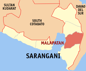
Malapatan
Malapatan is a philippine municipality in the province Sarangani in Region XII SOCCSKSARGEN which belongs to the Mindanao group of islands. The municipality Malapatan is seated about 13 km south of province capital Alabel and about 1,068 km south-south-east of Philippine main capital Manila.
Malapatan is a 1st class municipality. Regarding urbanization Malapatan is classified as partly urban. Malapatan occupies an area of 609.28 km². By the end of 2007 Malapatan was the home of 65,605 residents. Thus by average 107.68 people are living on one km².
Administratively the Municipality of Malapatan is subdivided into 12 barangays. One forms the center of the city wheras the other 11 are in the outlying areas. Some of them are even several kilometers away from the center of the Municipality. The most populous are Libi, Patag, Sapu Padidu, Daan Suyan, Lun Masla, Kihan, Tuyan, Upper Suyan, Sapu Masla,Kinam, Lun Padidu, Poblacion (Malapatan).
Among the bigger cities and municipalities in the neighborhood of Malapatan there are Malita (Davao Del Sur) 50 km north-east, Sultan Kudarat (Nuling) (Maguindanao) 96 km north-west, General Santos City (Dadiangas) (South Cotabato) 19 km north-west, City Of Digos (Davao Del Sur) 88 km north, Polomolok (South Cotabato) 36 km north-west, City Of Koronadal (South Cotabato) 76 km north-west, Malungon 41 km north,Glan 19 km south-south-west, Santa Cruz (Davao Del Sur) 97 km north as well as 12 km north of Malapatan the municipality Alabel.
Source: http://www.philippine-islands.ph/en/malapatan-sarangani-philippines.html
https://en.wikipedia.org/wiki/


Leave a comment
Comments 0